Ramblers Cymru Logo Image of Countryside
Swansea Ramblers Logo
at the heart of walking


Swansea Ramblers Walk


Dylan's Birthday Walk and Wales Coast Path


Walk Start / Finish Location:
Laugharne Foreshore

Walk Distance: 6 miles ( 3 hours) with options for shorter walks

Walk Level: Moderate - Some uneven ground

Parking: Laugharne Foreshore (Free)

Transport: Traveline - www.traveline.info   - or - Telephone 0871 200 22 33


Walk Description


Facing seaward in the car park, turn right and follow the foreshore to the Dylan's Birthday Walk sign.
Ascend past information boards to 'The last verse'.
Magnificent views over the estuary that inspired Dylan can be seen.

(At this point you can shorten the walk by retracing steps to complete a 1.5 mile walk).

Continue on the coast path, descending to a stile and a broad flat path.
Continue about 100 yards to a stile on the left.

(At this point you can shorten the walk by continuing on broad path to Salt House Farm
and follow directions from Salt House Farm as described further below
).

Cross stile then bear left along the sea wall. N.B. high tides can cover this path.
Look across the estuary for views of Laugharne and Dylan's boat house from an angle not seen for many years.

N.B.Take care at this next junction NOT to enter any of the dangerous MOD firing range!
Where the sea wall bears left towards an MoD sign, continue straight on over a stile to the right of the sea wall which takes you onto a narrow and very uneven path.

AT THIS POINT DO NOT CONTINUE ON THE SEA WALL INTO THE MOD RESTRICTED ZONE (WHICH IS INDICATED BY WARNING SIGNS)
After this walk, if you decide to visit the beach, watch out for unexploded ordnance!
You can download the local advice about ordnance here or go to their website at qinetiq.com

Also, watch out for the natural dangers along this right of way since there are potholes and trip hazzards!
When this curves right to a stile, cross the stile then go diagonally right to the southern fence rather than straight on the overgrown narrow path.
Continue to East House Farm which can be clearly seen in the distance.
At the farm you might be greeted by pigs and chickens on their side of the fence.
The beach is not accessible from this path because of the MoD land.
Turn inland along the farm track to a minor road, turn right then almost immediately go left over a stile.
A herd of young cows might crowd around you in one of these fields so take care.
Continue inland to a footbridge, turn right onto the farm track then just before the gate go left down the bank.
Cross more stiles and follow the left edge of the field to Salt House Farm and the broad track that you left at the sea wall.

Directions from Salt House Farm
(At this point you can shorten the walk by turning right on the broad track - back to Dylan's Birthday Walk).

(The path is unclear and unsigned here but is actually at the back of the farmyard and becomes more defined after climbing above the yard).
Continue straight on into the farmyard between the farmhouse and the farm shed to the unsigned footpath
that climbs straight up (to the right of a caravan) onto the hillside path and eventually reaches a signed junction in the woods.

(At this point you can shorten the walk by continuing straight on at this woodland junction back to the Birthday walk)

Here at this signed woodland junction turn left uphill to wooden steps and continue uphill to a field,
there taking in the coastal panorama overlooking where you have been walking. Watch for Worm's Head in Gower across the water.
Cross a stone stile to the next field and continue slightly right to descend to a single track road.
Go down the road watching for Dylan's house in the distance after you turn the bend.
A footpath sign at a road junction goes right - down a lane
and takes you straight through a farmyard to a hidden stile at the other end to the right of the house and down a path back to the foreshore.
The path emerges onto the foreshore.
Turn left to the finish.


Ramblers Cymru and Swansea Ramblers provide these routes but accept no responsibility for those walking them.

If you would like to go on a walk but would prefer to do so with a group of people then click on our Programme section to see what walks we are leading.

We have walks for varying levels of ability and you get the chance to see the countryside in places you might never go by yourself!


Maps of the Walk


Ordnance Survey map of the route to walk
Resizable and draggable
(Can be reset to original dimensions by refreshing the page)
Green Swansea Ramblers logo markers where present can be clicked to provide more information


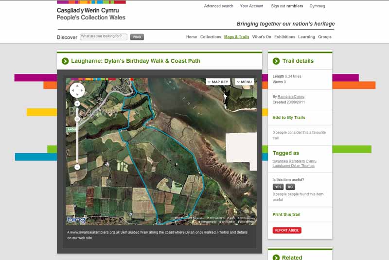
This aerial map is resizable and draggable
(Can be reset to original dimensions by refreshing the page)

A 25,000 Ordnance Survey map of the area
can be viewed by clicking on the above 'View Larger Map' option
(applies only if the above is a Bing map, not a Google map )


Peoples Collection link

The route of this walk has been added to The National Museum of Wales' Peoples Collection Web site.
A choice of aerial imagery or historic Ordnance Survey mapping is available.
Click the map to enter their web site (opens in a new browser window)
or copy and paste this link into a new browser window.
http://www.peoplescollectionwales.co.uk/Trail/770-laugharne-dylans-birthday-walk-coast-path


Photographs of the Walk


Photograph of Walking Route - Image 1
Laugharne Car Park


Photograph of Walking Route - Image 2
Follow coast path


Photograph of Walking Route - Image 3
View of Laugharne Castle


Photograph of Walking Route - Image 4
Ignore first right of way


Photograph of Walking Route - Image 5
Ascend the Dylan Birthday Walk


Photograph of Walking Route - Image 6
View of the Boathouse


Photograph of Walking Route - Image 7
Watch out for the Wales Coast Path signs


Photograph of Walking Route - Image 8
Information boards along the way


Photograph of Walking Route - Image 9
Go through the gate onto Salt House land


Photograph of Walking Route - Image 10
Panorama over the estuary


Photograph of Walking Route - Image 11
Descend to sea level


Photograph of Walking Route - Image 12
Last section of the birthday walk


Photograph of Walking Route - Image 13
Go down the steps


Photograph of Walking Route - Image 14
Follow the level path for 100 yards


Photograph of Walking Route - Image 15
Cross stile and the dam
(or shorten by continuing on level path to Salt House Farm)


Photograph of Walking Route - Image 16
Keep to left of the sea wall


Photograph of Walking Route - Image 17
Watch for the boathouse


Photograph of Walking Route - Image 18
Follow sea wall - watch out for high tides


Photograph of Walking Route - Image 19
Follow sea wall


Photograph of Walking Route - Image 20
Carry straight on when sea wall curves left and use a stile to the right of the sea wall
DO NOT CONTINUE ALONG THE SEA WALL INTO THE DANGEROUS MOD FIRING RANGE
Please observe all warning signs and do not enter any restricted zones


Photograph of Walking Route - Image 21
Rough and potholed underfoot


Photograph of Walking Route - Image 22


Photograph of Walking Route - Image 23
Path curves right


Photograph of Walking Route - Image 24
Take stile on left


Photograph of Walking Route - Image 25
Cross diagonally right towards fence


Photograph of Walking Route - Image 26
Head for East House Farm


Photograph of Walking Route - Image 27
Turn inland at the farm


Photograph of Walking Route - Image 28
Might see some pigs


Photograph of Walking Route - Image 29
Turn inland on the farm track


Photograph of Walking Route - Image 30
Farm track heading north and inland


Photograph of Walking Route - Image 31
At the minor road turn right then left


Photograph of Walking Route - Image 32
This minor road has a staggered junction of paths


Photograph of Walking Route - Image 33
Follow the field boundary


Photograph of Walking Route - Image 34
Can be muddy due to cattle


Photograph of Walking Route - Image 35
Follow the field boundary


Photograph of Walking Route - Image 36
Watch out for the cows that may crowd around


Photograph of Walking Route - Image 37
Follow the field boundary towards Salt House Farm


Photograph of Walking Route - Image 38


Photograph of Walking Route - Image 39
Watch for the path leaving the track to a gate and stile


Photograph of Walking Route - Image 40
Turn left along edge of field then follow field boundary right to farm


Photograph of Walking Route - Image 41
Approaching Salt House Farm


Photograph of Walking Route - Image 42
Go through lower gate and go straight across into farm yard


Photograph of Walking Route - Image 43
Carry straight on through farmyard to an unsigned path onto the hill


Photograph of Walking Route - Image 44
View back from path above farmyard


Photograph of Walking Route - Image 45
Looking back to where you just walked through Salt House farmyard


Photograph of Walking Route - Image 46
Ruin in undergrowth


Photograph of Walking Route - Image 47
Turn uphill at the junction
(or shorten by going straight on to Dylan's Birthday Walk)


Photograph of Walking Route - Image 48
View of same junction to turn uphill. This view changes with the seasons!


Photograph of Walking Route - Image 49
Wooden steps


Photograph of Walking Route - Image 50
Carry straight on uphill to next stile into the field


Photograph of Walking Route - Image 51
The stile into the field


Photograph of Walking Route - Image 52
From that field look back at the view


Photograph of Walking Route - Image 53
Meadow full of summer flowers (May)


Photograph of Walking Route - Image 54
Over the stone stile


Photograph of Walking Route - Image 55
View from stile - path goes slightly right to the road


Photograph of Walking Route - Image 56
Descend the road


Photograph of Walking Route - Image 57
Descend the road


Photograph of Walking Route - Image 58
Descend the road


Photograph of Walking Route - Image 59
Watch for Dylan's Boathouse


Photograph of Walking Route - Image 60
Turn right at the junction


Photograph of Walking Route - Image 61
Follow the farm track


Photograph of Walking Route - Image 62
Go through farmyard


Photograph of Walking Route - Image 63
Go straight on towards the last house


Photograph of Walking Route - Image 64
Stile is hidden in a dip to the side of the house


Photograph of Walking Route - Image 65
Don't worry! You are still on the right of way!


Photograph of Walking Route - Image 66
Down a concrete path


Photograph of Walking Route - Image 67
Back onto the Wales Coast Path


Photograph of Walking Route - Image 68
Return to the car park


More information about walking in Wales is available at:    www.ramblers.org.uk/wales

Ramblers Cymru and Swansea Ramblers provide this route but accept no responsibility for those walking it

All photographs Copyright 2012 Andrew Morgan. All rights reserved


Swansea Ramblers hope you enjoy doing this walk.

Over time things can change on the walk

- for example - path diversions, new gates instead of stiles or maybe the path has become blocked.

If you do find anything different on the way then let us know:

1. Which walk you have been on.

2. The type and location of the change or the problem you have experienced.


Of course you may just like to tell us that you have done the walk and whether you enjoyed it.

Use the link below to email us about your walk.

We'll look forward to hearing from you.


If the email link is not displayed above or is not supported by your email setup, manually type in our email address
address


Back to top

Our use of Cookies

Our Privacy Policy


Valid HTML 4.01 Transitional