June
|
Saturday 13th June |
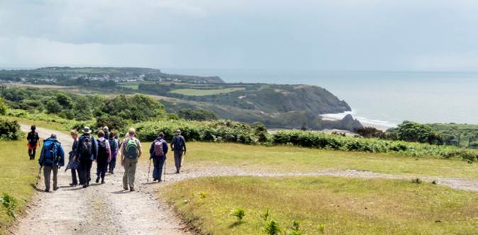
Coach Walk Tintern to Chepstow Pre-booking essential |
|
|
Leader: Tim Gronow |
6 miles |
|
|
Tel: Lynne Esson 01792 845845 or 07754 435221 |
Leisurely |
|
|
Description:
The Social Committee has arranged a coach to take us to Tintern for a walk from Tintern to Chepstow.
We will start our walk from Tintern Abbey, cross the river using the refurbished bridge then follow the old railway line along the Wye Valley.
On the way, we’ll pass through the re-opened Tidenham Tunnel to Netherhope.
We will leave the railway at this point to either pick up Offa’s Dyke path or the Gloucestershire Way path, either of which will lead us to Chepstow Castle Car Park.
Terrain: The walk will be mostly on good surfaces but fields may be soft and muddy.
The cost will be £14.00.
We will pick up the coach at the Brangwyn Hall entrance of the Guildhall at 9.00 am.
The journey will take approximately 1.5 hours.
We will leave Chepstow Castle Car Park at 5.30 p.m.
Please book your seat with Lynne before making your payment
Cancellation: If you find you can no longer attend this event, please contact Lynne as soon as possible as there may be a waiting list.
|
||
|
Sunday 14th June |
Cwmllynfell |
||||||||||
|
Leaders: Pete Marsh & Paul Scutchings |
8 miles |
||||||||||
|
Tel: 07826-827137 (Pete) 07725-856484 (Paul) |
Moderate Ascent: 800 ft (243 m) |
||||||||||
|
|
|
||||||||||
|
Description:
Weather permitting, there will be superb views of the Black Mountains.
The walk will start on a disused railway in the direction of Rhosamman.
We then skirt around and overlook Brynamman, walk towards Tairgwaith then heading back towards the car park through the village.
Terrain: Good underfoot but use of walking poles is advised.
Social after walk: Afterwards, we will go for refreshments to a suitable venue. |
|||||||||||
|
|
|||||||||||
|
|
Dogs on Short Leads |
||||||||||
|
Start: |
Starting Place: |
|
|||||||||
|
10:00 a.m. |
Cwmllynfell: Car park north of village. |
||||||||||
|
Directions: · From Swansea take the A4067 to Gurnos. · Take first exit on roundabout to the A4068 (Bethel Road). · Continue through Cwmtwrch Isaf and Ystradowen. · On leaving the village of Cwmllynfell, turn left into parking area. · (Tarmac car park).
|
|||||||||||
|
(Members can use the FREE Ramblers App as a Sat Nav to all our walks) |
|||||||||||
|
What3Words: ambient.superhero.insert |
Post Code: SA9 2GX |
||||||||||
|
Lat/Long: 51.8032, -3.8258 |
|
GR: |
SN |
742 131 |
|||||||
|
Wednesday 17th June |
The Top Paths – Bishopston, Holtsfield, Caswell Valley |
||||||||||
|
Leader: Clive Scott |
6 miles |
||||||||||
|
Tel: 07367-299198 |
Moderate |
||||||||||
|
|
|
||||||||||
|
|
|
||||||||||
|
Description:
A coastal and inland walk with fine views.
The South Gower Rugby Club have kindly given us permission to park in their private car park.
The walk passes through the attractive village of Bishopston and across Holts Field with its open views over the surrounding countryside.
The route then follows the upper path through Caswell Valley where woodland and wildlife provide a peaceful backdrop.
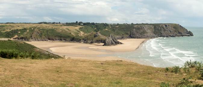
Reaching the clifftops, the coastal path offers impressive views across the bay and along the rugged Gower coastline. _________________________________________
Lunch A descent into Caswell Bay provides an ideal stop for lunch by the sea. _________________________________________
The return journey follows the upper path above Brandy Cove. This combines dramatic coastal scenery with quiet natural surroundings.
We then continue through countryside to our starting point.
Stiles: None. Toilets: Caswell Bay. Terrain: · Undulating paths, especially by the coast (and in places rough). · Some ascent. · This walk is unsuitable for young children.
Social after walk: Afterwards, we will go for refreshments to the Joiners in Bishopston.
|
|||||||||||
|
|
|||||||||||
|
Walking across Caswell Bay |
|||||||||||
|
The view from the coast path |
|||||||||||
|
|
|||||||||||
|
|
Dogs remain on short leads |
||||||||||
|
Start: |
Starting Place: |
|
|||||||||
|
10:30 a.m. |
Bishopston: Pyle Corner: South Gower Rugby Club (Free) |
||||||||||
|
Directions: · From Swansea, follow A4067 towards Mumbles. · At Blackpill, turn right to ascend the Mayals (B4436). · Continue straight on for 2 miles. · Pass Northway Filling Station. · Descend and turn left at the junction for Bishopston. · Follow this village road for just under a mile to Pyle Corner. · Turn 2nd right at the bend in the road at Pyle Corner. · Head west on Pwlldu Lane. · After 400 feet, turn left at the junction to follow a single-track lane. · Turn right in just under a quarter of a mile at the Rugby Club.
|
|||||||||||
|
(Members can use the FREE Ramblers App as a Sat Nav to all our walks) |
|||||||||||
|
What3Words: congas.birdcage.isolated |
Post Code: SA3 3DX |
||||||||||
|
Lat/Long: 51.5725, -4.0520 |
|
GR: |
SS |
578 879 |
|||||||

|
20th June |
Mynydd Illtud from Beacon’s Visitor Centre |
||||||||
|
Leader: Mike Clarke |
5.5 miles |
||||||||
|
Tel: 07837-411220 |
Leisurely |
||||||||
|
|
|
||||||||
|
|
|
||||||||
|
Description:
A beautiful walk around Mynydd Illtud with glorious mountain views in all directions.
We’ll have a gradual climb up to the Trig Point overlooking the Usk Valley.
Stiles: None Toilets: At the visitor centre Terrain: Grassland. Some gentle ascents
Social after walk: Afterwards, we will go for refreshments to the mountain centre.
|
|||||||||
|
|
|||||||||
|
Pen y Fan in the distance |
|||||||||
|
|
|||||||||
|
A Tea break looking northwards |
|||||||||
|
|
Dogs remain on short leads |
||||||||
|
Start: |
Starting Place: |
|
|||||||
|
11:00 a.m. |
Libanus: Brecon Beacons Mountain Centre car park (pay & display)
|
||||||||
|
Directions: · Drive to Defynnog on the A4067. · Turn right onto the A4215. · After leaving the village, take the 3rd left at crossroads. · Continue on minor road for a further 1.5 miles. · Turn right and continue for 0.5 miles, passing farm buildings. · Turn left to the visitor centre.
|
|||||||||
|
(Members can use the FREE Ramblers App as a Sat Nav to all our walks) |
|||||||||
|
What3Words: added.splints.bared |
Post Code: LD3 8ER |
||||||||
|
Lat/Long: 51.9250, -3.4884 |
|
GR: |
SN |
978 263 |
|||||

|
Sunday 21st June |
Pontardawe Circular |
|||||||||
|
Leaders: Chris Barton & Elaine Reed |
9 miles |
|||||||||
|
Tel: 07976-833538 (Chris) 07790-605550 (Elaine) |
Moderate |
|||||||||
|
|
|
|||||||||
|
Description:
We’ll head north from Pontardawe on footpaths to the Gleision Miners’ Memorial, returning on St. Illtud’s Walk and down Cwm Du Glen.
Social after walk: Afterwards, we will go for refreshments to a suitable venue. |
||||||||||
|
|
||||||||||
|
|
Assistance Dogs Only |
|||||||||
|
Start: |
Starting Place: |
|
||||||||
|
10:00 a.m. |
Pontardawe: Glantawe Riverside Park |
|||||||||
|
Directions: · Head north on the A4067 towards Brecon. · At Pontardawe, continue on A4067 past the roundabout for Tesco’s. ·
At the next roundabout, take
the first exit. · Park on road.
|
||||||||||
|
What3Words: wage.landowner.contemplate |
Post Code: SA8 4PP |
|||||||||
|
Lat/Long: 51.7282, -3.8370 |
|
GR: |
SN |
732 048 |
||||||
|
Thursday 25th June |
Three Cliffs A Taste of Gower Walk |
|||||||||
|
Leader: Lynne Esson |
3-4 miles |
|||||||||
|
Tel: 07754-435221 or 01792-845845 |
Leisurely |
|||||||||
|
|
|
|||||||||
|
|
|
|||||||||
|
Description:
Please note the start time to allow for public transport.
From the car park we will walk down to Three Cliffs Bay.
Depending on whether the tide is in or out will decide which side of Pennard Pill we walk to the Gower Heritage Centre.
We will return via the Drovers’ road to the cars.
This walk will take between 2 and 3 hours.
Stiles: None. Toilets: Gower Heritage Centre. Terrain: Sandy / mud / stony. Public Transport: Bus No 118 from The Quadrant (Please check the time nearer the day)
Social after walk: Afterwards, we will go for refreshments to the Gower Inn for drinks / coffees. |
||||||||||
|
|
||||||||||
|
|
Dogs remain on short leads |
|||||||||
|
Start: |
Starting Place: |
|
||||||||
|
10:00 a.m. |
Penmaen: National Trust car park. (Behind St John’s Baptist Church).
|
|||||||||
|
|
||||||||||
|
Directions: · Take the A4118 heading to Oxwich. · Go through Parkmill. · Take 1st right at top of hill. · Pass the Church of St. John the Baptist. · Go over a cattle grid. · Turn immediately right onto a rough surface track. · Park here. |
||||||||||
|
|
||||||||||
|
(Members can use the FREE Ramblers App as a Sat Nav to all our walks) |
||||||||||
|
What3Words: booklets. gourmet. Climbing |
Post Code: SA3 2HQ |
|||||||||
|
Lat/Long: 51.5788, -4.1210 |
|
GR: |
SS |
531 887 |
||||||

|
25th June |
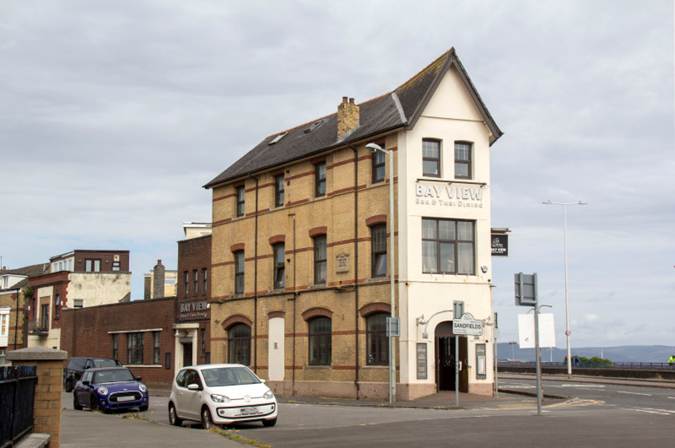
Social Evening: Evening Meal at The Bay View (Plus, Leaders’ meeting to plan the next programme) |
||||||
|
|
|||||||
|
|
|||||||
|
The Bay View Hotel |
|||||||
|
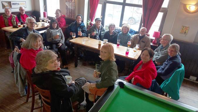
We will be visiting the Bay View Hotel where we can enjoy a Thai meal.
Please note this will be on a Thursday evening.
Our previous social events with a Thai meal at the Bay View have always been enjoyed by us.
While the social is taking place, we will also be putting together the next programme, so if you are able to lead a walk, please think about a one (or more) that you could do for the group.
New Leaders: If you have never led before then have a chat with us; we will help you get started.
Maybe you could begin with an easy walk such as an evening stroll or a short walk on a Sunday or weekday. It’s not as hard as you think!
|
|||||||
|
|
|||||||
|
|
|||||||
|
Enjoying a previous social at the Bay View Hotel |
|||||||
|
|
|||||||
|
Parking: On-street parking is available in Francis Street and around the Guildhall. |
|||||||
|
|
|||||||
|
Meet: |
Meeting Place: |
|
|||||
|
7:00 p.m. |
The Bay View Hotel: (Near Guildhall)
|
||||||
|
Directions: The Bay View Hotel is on junction of Oystermouth Road (A4067) and St. Helen’s Road, near the Guildhall.
|
|||||||
|
What3Words: covers.games.supper |
Post Code: SA1 3UL |
||||||
|
Lat/Long: 51.6127, -3.9591 |
GR: |
SS |
644 922 |
||||


|
Saturday 27th June |
A Morning LINEAR Walk: Gowerton to Penclawdd (see the other entry for the afternoon walk) |
||||||||||
|
Leader: Peter Jones |
4 miles |
||||||||||
|
Tel: 07840-542048 |
Leisurely |
||||||||||
|
|
|
||||||||||
|
|
|
||||||||||
|
Description:
N.B. This is a linear walk starting in Gowerton and finishing in Penclawdd.
Peter will also lead a second linear walk back to Gowerton or you may wish to catch a 116 bus back from Penclawdd to Gowerton.
This is a lovely inland walk to Penclawdd along lesser-used paths and Bridleways. From the Golf Course, there will be fine views over Loughor Estuary.
After joining Cefn Stylle Road for a few hundred yards, we’ll descend to a footpath with more views across the estuary before joining the Active Travel Path into Penclawdd.
In Penclawdd we will stop for lunch. You may like to visit the café or enjoy Fish and Chips whilst looking out across the Loughor Estuary (or maybe have an ice-cream in GG’s Gelateria!).
You will then have the option to join Peter on the afternoon walk back to Gowerton.
Stiles: There are 2 stiles along the way. Toilets: There are toilets available in Penclawdd. Terrain: · Brambles and undergrowth along the way. · Some ascent, some mud, uneven surfaces. · Busy roads to traverse, including 500 yards along Cefn Stylle Road.
|
|||||||||||
|
|
Dogs remain on short leads |
||||||||||
|
Starting Place: |
|
||||||||||
|
11:00 a.m. |
Gowerton: Brynymor Road (on-street parking) |
||||||||||
|
Directions: · Head west on the B4295 Cockett to Gowerton. · Turn left at traffic lights into Sterry Road. · Continue straight at mini roundabout (onto B4296). · At traffic lights, continue straight onto Brynymor Road. · Park after passing rear of Tesco Petrol Station.
|
|||||||||||
|
(You can use the Ramblers App as a Sat Nav to all our walks) |
|||||||||||
|
What3Words: late.landscape.promote |
Post Code: SA4 3EZ |
||||||||||
|
Lat/Long: 51.6492, -4.0474 |
|
GR: |
SS |
584 964 |
|||||||
|
|
|||||||||||
|
|
|||||||||||
|
Peter leading a previous walk through Penclawdd |
|||||||||||

|
Saturday 27th June |
An Afternoon LINEAR Walk: Penclawdd to Gowerton (see the other entry for the morning walk) |
||||||||||
|
Leader: Peter Jones |
3.5 miles |
||||||||||
|
Tel: 07840-542048 |
Leisurely |
||||||||||
|
|
|
||||||||||
|
|
|
||||||||||
|
Description:
N.B. This is a linear walk starting in Penclawdd and finishing in Gowerton.
The walk one-way to Gowerton is about 3.5 miles. Those wishing to return to Penclawdd could catch a 116 bus from Gowerton.
We will begin our walk along the Penclawdd Foreshore (with a small section that may be wet and muddy). We then join the Tarmacadam Active Travel Path eastward.
From here we cross the B4295 at the Rake and Riddle to join the inland section of the Wales Coast Path.
From the hills over which the coast path travels, we will have fine views above the Loughor Estuary and beyond.
We then continue east on an enclosed Bridleway until we reach Cefn Stylle Road. A short distance on the road brings us to an awkward stile.
Continuing through a field and woodland, the coast path emerges onto Brynymor Road where our walk finishes.
Stiles: There is one stile (awkward) along the way. Toilets: There are toilets available in Penclawdd. Terrain: Some ascent, some mud and a Bridleway with a rocky surface.
Social after walk: Afterwards, we will go for refreshments to The Farmers Arms in Swansea Road, Waunarlwydd. |
|||||||||||
|
|
Dogs remain on short leads |
||||||||||
|
Starting Place: |
|
||||||||||
|
2:00 p.m. |
Penclawdd: Foreshore Car Park (free) |
||||||||||
|
Directions: · From Gowerton, follow B4295 westward to Penclawdd · Negotiate the double bend in the village · Pass over the pedestrian crossing · Turn immediately right into the car park (The Chip shop is to the left and GGs is to the right)
|
|||||||||||
|
(You can use the Ramblers App as a Sat Nav to all our walks) |
|||||||||||
|
What3Words: pining.skillet.area |
Post Code: SA4 3YF |
||||||||||
|
Lat/Long: 51.6429, -4.1038 |
|
GR: |
SS |
545 958 |
|||||||
|
|
|||||||||||
|
|
|||||||||||
|
Peter leading a previous walk through Penclawdd |
|||||||||||
|
Sunday 28th June |
Tywi Forest |
|||||||||
|
Leader: Tim Gronow |
10 miles |
|||||||||
|
Tel: 07710-231630 |
Moderate |
|||||||||
|
|
|
|||||||||
|
Description: N.B. This walk was originally scheduled for 9th August.
A forest and moorland walk in the Irfon Valley.
Social after walk: Afterwards, we will go for refreshments to a suitable venue. |
||||||||||
|
|
||||||||||
|
|
Assistance Dogs Only |
|||||||||
|
Meet: |
Meeting Place: |
|
||||||||
|
08:30 a.m. |
Cross Hands: Heol Parc Mawr N.B. We will car-share to Abergwesyn. |
|||||||||
|
Directions: · Follow A48 west to Cross Hands Business Park. ·
Just before Cross Hands, exit
left on slip road, · At top of slip road, take 3rd exit off roundabout. · Take 2nd exit at next roundabout. · At next roundabout, take 1st exit onto Heol Parc Mawr.
|
||||||||||
|
What3Words: booms.fortress.charted |
Post Code: SA14 6RB |
|||||||||
|
Lat/Long: 51.7963, -4.0791 |
|
GR: |
SN |
567 128 |
||||||